
# Transcription
Uploaded Image
Transcribed Text
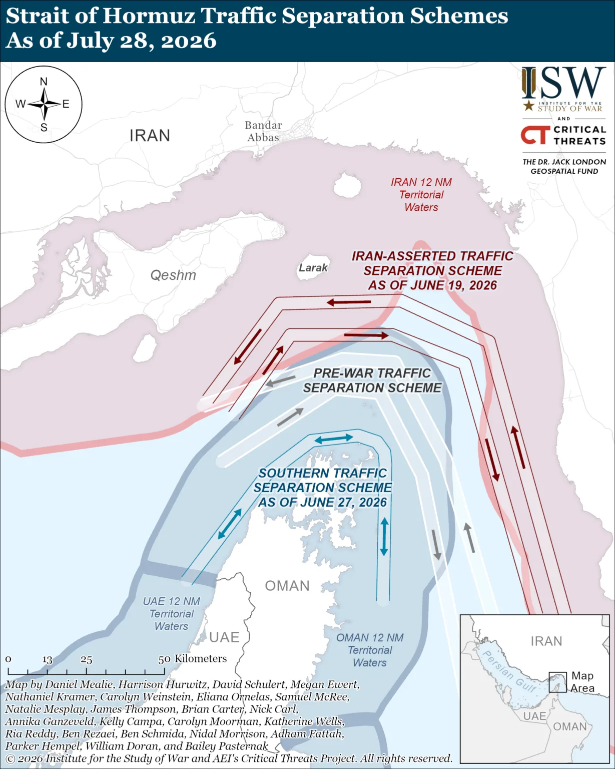
The image is a geospatial situation map attributed to the Institute for the Study of War (ISW) and the American Enterprise Institute's Critical Threats Project (CTP), depicting competing traffic separation schemes (TSS) in the Strait of Hormuz as of 28 July 2026.
Full analysis The complete summary ⌄
The image is a geospatial situation map attributed to the Institute for the Study of War (ISW) and the American Enterprise Institute's Critical Threats Project (CTP), depicting competing traffic separation schemes (TSS) in the Strait of Hormuz as of 28 July 2026. The core substantive claims are strongly corroborated by primary institutional statements (IMO), major wire and newspaper reporting (Reuters via Al-Monitor/US News, The National, Asharq Al-Awsat), and specialist maritime and think-tank sources (Maritime Executive, Lloyd's List, Splash247, The Washington Institute). Confirmed elements include: the existence of the IMO 'pre-war'/traditional TSS (adopted 1968); Iran's redrawn, IRGC-linked scheme routing inbound traffic between Qeshm and Larak (the 'Tehran toll booth') with outbound traffic south of Larak; an Oman/UN-coordinated southern route established in late June 2026; the 12-nautical-mile territorial-sea claims of Iran, Oman and the UAE; and the authorship/funding attribution (ISW-CTP, Dr Jack London Geospatial Fund). The specific internal date labels on the map ('as of June 19, 2026' for the Iran-asserted scheme and 'as of June 27, 2026' for the southern scheme) could not be independently confirmed to the exact day and are marked Unverified, though they fall within well-documented timelines. No claim rose to the threshold of being marked False. Overall the map reflects an accurately-sourced, evolving real-world situation, warranting a high trust score, with modest deductions for unverifiable precise date labels and the inherently fast-changing nature of the maritime dispute.
What checked out (9)
- The map is attributed to the Institute for the Study of War (ISW) and AEI's Critical Threats Project (CTP); these two bodies routinely co-produce open-source situation maps and analysis, frequently in partnership. [criticalthreats.org; iranmonitor.org]
- The ISW geospatial/mapping program is enabled by the 'Dr. Jack London Geospatial Fund', established in 2022 by Dr Jennifer London in honour of her late husband. [x.com/TheStudyofWar; nmdf.org; jmu.edu]
- A pre-war / traditional Traffic Separation Scheme exists in the Strait of Hormuz; it was proposed by Iran and Oman and adopted by the IMO in 1968 and is described by the IMO as the only recognised route through the Strait. [imo.org]
- Iran (via its Ports and Maritime Organization / Persian Gulf Strait Authority) published a redrawn traffic separation scheme in 2026, citing the risk of anti-ship mines, requiring vessels to coordinate with the IRGC Navy. [maritime-executive.com; euronews.com]
- Iran's redrawn scheme routes inbound traffic between the islands of Qeshm and Larak (the so-called 'Tehran toll booth' corridor) with the outbound lane running just south of Larak, keeping vessels within Iranian territorial waters and IRGC reach. [maritime-executive.com; splash247.com; wionews.com]
- A southern route/corridor along Oman's coast was established in coordination with the UN/IMO in late June 2026 (two temporary routes, one north and one south of the existing TSS were announced ~24 June 2026). [thenationalnews.com; english.aawsat.com]
- Iran, Oman and the UAE each claim 12-nautical-mile territorial seas in and around the Strait of Hormuz, leaving no high-seas corridor. [lawdisorder.substack.com]
- As of 28 July 2026, Iran was pressing Oman over control of Hormuz transit lanes, rejected an equal-division proposal, and stated it no longer recognised the IMO TSS and had never recognised the southern route along Oman's coast — consistent with a map dated 'As of July 28, 2026'. [al-monitor.com / Reuters; usnews.com]
- Geographic labels on the map (Iran, Bandar Abbas, Qeshm, Larak, UAE, Oman, Persian Gulf) are accurate real-world features of the Strait of Hormuz region. [strausscenter.org; betterworldcampaign.org]
Unverified claims 4 claims ⌄
- The precise date label 'IRAN-ASSERTED TRAFFIC SEPARATION SCHEME AS OF JUNE 19, 2026' — the Iran-asserted scheme is well documented (first widely reported April 2026 and updated through May–July 2026), but the exact 19 June 2026 effective date could not be independently confirmed to the day.
- The precise date label 'SOUTHERN TRAFFIC SEPARATION SCHEME AS OF JUNE 27, 2026' — the Oman/UN southern corridor was announced around 24 June 2026, so 27 June is plausible and near-contemporaneous, but the exact 27 June 2026 label could not be independently confirmed to the day.
- The exact cartographic geometry of the plotted lanes, buffer zones and 'transit prohibited' danger zone as drawn on this specific map could not be pixel-verified against a primary source; the described routing is, however, consistent with reporting.
- The full accuracy and completeness of the individual analyst credit list (23 named contributors) cannot be verified from open sources; such credit lines are standard for ISW-CTP products but were not individually confirmed.
Sources & how we checked Search journal, source grades, confidence ⌄
Confidence
High — Confidence is high because the map's substantive, verifiable claims (existence and 1968 IMO origin of the pre-war TSS; Iran's IRGC-linked Qeshm–Larak scheme; the Oman/UN southern corridor; 12nm territorial claims; ISW-CTP authorship; Dr Jack London Geospatial Fund) are each corroborated by multiple independent, dated, reputable sources including a primary intergovernmental body (IMO) and Reuters wire reporting dated to the map's stated date of 28 July 2026. Confidence is not 'Very High' because the two precise internal effective-date labels (19 June and 27 June 2026) and the exact plotted lane geometry could not be confirmed to the day/pixel level, and the subject matter is fast-moving, warranting the residual uncertainty reflected in the Unverified items and the 12-point deduction from a perfect score.
Search journal
Institute for the Study of War Critical Threats Project Iran
- https://www.criticalthreats.org/the-project
- https://www.criticalthreats.org/analysis/institute-for-the-study-of-war-and-aeis-critical-threats-project-l...
Strait of Hormuz traffic separation scheme
- https://www.imo.org/en/mediacentre/hottopics/pages/middle-east-strait-of-hormuz.aspx
- https://maritime-executive.com/article/iran-publishes-redrawn-traffic-scheme-for-strait-of-hormuz
Al-Monitor Iran temporary Hormuz plan July 28 2026 southern lane Oman two lanes
- https://www.al-monitor.com/originals/2026/07/iran-proposes-temporary-hormuz-plan-giving-itself-greater-cont...
- https://www.usnews.com/news/world/articles/2026-07-28/iran-proposes-temporary-hormuz-plan-giving-itself-gre...
Maritime Executive Iran redrawn traffic scheme Qeshm Larak inbound outbound IRGC
- https://maritime-executive.com/article/iran-publishes-redrawn-traffic-scheme-for-strait-of-hormuz
- https://splash247.com/near-standstill-at-hormuz-with-ceasefire-failing-to-unlock-gulf-shipping/
- https://www.wionews.com/world/tehran-toll-booth-iran-announces-alternative-routes-in-hormuz-why-is-it-forci...
IMO middle east Strait of Hormuz June 27 2026 traffic separation scheme statement
- https://www.imo.org/en/mediacentre/pressbriefings/pages/no-safe-transit-through-hormuz-imo-secretary-general.aspx
- https://www.imo.org/en/mediacentre/hottopics/pages/middle-east-strait-of-hormuz.aspx
Oman southern traffic separation scheme Strait of Hormuz June 2026 established new lane
- https://www.thenationalnews.com/news/gulf/2026/06/24/oman-and-un-set-up-corridor-for-safe-passage-of-ships-...
- https://english.aawsat.com/gulf/5287905-oman-opens-temporary-strait-hormuz-shipping-routes-says-no-tolls-wi...
Dr Jack London Geospatial Fund ISW Institute for the Study of War
- https://x.com/TheStudyofWar/status/1654532865512689665
- https://nmdf.org/jennifer-london-phd/
- https://www.jmu.edu/news/cisr/2022/10/261-2/03-261-mathews.shtml
Iran twelve nautical mile territorial waters Strait of Hormuz UAE Oman
- https://lawdisorder.substack.com/p/the-law-of-the-sea-what-is-the-legal
- https://www.euronews.com/2026/05/22/iran-asserts-jurisdiction-over-uae-and-oman-waters-in-new-strait-of-hormuz-map
Washington Institute Iran navigational order Hormuz June 2026 southern route Omani waters
- https://www.washingtoninstitute.org/policy-analysis/iran-still-intent-preventing-return-old-navigational-order
- https://www.rferl.org/a/iran-strait-hormuz-raydan-shipping/33799680.html